

It is a fascinating part of Ethiopia which has been referred to us as “the hottest place on earth”, the most hostile place on earth”, and “the lowest place on earth”, the Afar Triangle”. All these claims are somewhat exaugurated, but they convey a picture of the region’s –vast, arid landscape, dusty plains, black volcanic basalt rocks, salt flats dotted with volcanic ranges, massifs and dropped down to 116 meters (about 380.58 ft) below sea level.
This is home to the nomadic Afar people who are predominantly Islamic in religion adapting the religion in the 13th C.A.D. from holy men and traders from Arabian Peninsula and today live in both Ethiopia, Eritrea, and Djibouti.] in small fertile grounds along the Awash Riverbank grow tobacco, maize and dates to supplement their diet. They are divided into different clan-based families led by elders and two other political and working classes.
They live in a very simple hut made from palm-fiber grass-matting dwellings which look like Igloos arranged in family groups surrounded by thorn hedges or mud walls to protect the people and their livestock from rival clans and wild animals.
In 1974 a group of researchers unearthed the oldest hominid fossils which have been claimed to be our ancestor; Lucy (Australopithecus Afarensis) a 3.2 m y old, in the very desolate section of the Awash valley, fully grown woman who once walked for the first time in this part of Africa whose skeleton is now in full display in the National Museum. This is the most welcomed finding in the science world and Ethiopians gave an Amharic name ‘Dinkenesh’ meaning “Too Wonderful”. Subsequent discoveries brought hominid fossils like the 3.3 my old Selam and others to put Ethiopia as a Cradle of Man Kind.
“Afar must be a geologically fascinating place on our planet, as it is the only place where the final breakup of the Continent and the early stage of the sea floor spreading can be seen on land actually happening”.
–Frances M. William–
Erta Ale: The smoking mountain
This is a typical Ethiopia’s famous basalt shield volcano known as the oldest active volcano in the world since 1906. It lies at an altitude of 613 m above sea level and has a 50 km (about 31.07 mi) diameter base. The summit crater has two elliptical active lava lakes, the large one, to the south, is 3km and the northern one is 1.5km large, respectively. The trek up to the crater rim is such a gentle slope along fresh lava of rhyolite, trachyte, and pitchstone.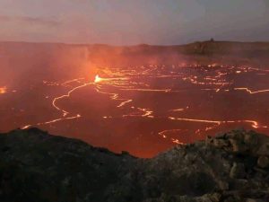
Dallol: The second lowest place on earth, 116m (about 380.58 ft.) below sea level
This is the most alluring place for any trip to this part of Ethiopia, and it is the second lowest point on our planet 116 m (about 380.58 ft) below sea level. It has been created through a geothermal process beneath several hundred meters of salt deposit. It is a broad low dome about 50m high and 3km in diameter at the Afar Triangle of the East African Rift System. A continuous noxious degassing of steaming fumaroles and minerals shapes and structures are all the resulting effects of the magmatic intrusion of salt. Dallol is a fairly recent feature, which happened just in the last 10,000 years after the sea evaporated leaving a desolate salt plain. Salt-saturated groundwater and magmatic fluid create extremely heated hot springs and bubble up to form such a spectacular yellow, green, brown, and massive terrace system. The fresh hot springs form it and precipitated with salt, the small salt mound builds up its outer layer, and the small amount of iron mixed with the salt becomes oxidized. The bright colors are due to various forms of iron oxide and hydro oxide mixed with salt and some deposits of Sulphur. Fluctuation of water level in the hydrothermal pool and being dried resulted in the formation of salt flowers or lilies, which are composed of mainly halite (NaCl). West of Dallol is dominated by splendid salt pinnacles formed through years of erosion and is rich in gypsum, Calcium sulfate, and clay which protect beneath the materials from erosion.
Lake Assale/ Karum.
This is the most alkaline lake in this part of Ethiopia and was created through frequent flooding of the Sea via the Gulf and Zula. It extends for about 40km (about 24.85 mi) north of the Erta Ale Range and lies at 120 m (about 393.7 ft) Below Sea Leve. This is where the traditional Salt Extraction is done by the local Afar People and carried on Camel to the high land where its demand is a great deal. It is not only common salt (NaCl), but also Salts of Potassium Chloride which are important to produce Fertilizer are available.
Lake Afdera. This is another lake south of the Erta Ale range and covers an area of 100km (about 62.14 mi) Sq and 125 m (about 410.1 ft) deep. It has the lowest-lying island in the world and its PH value is less which makes it home to a few fish species including the endemic Danakilia Franchetti and Pupfish (Aplanius Stiassnyea).
A special tour of the Danakil Depression is ideally convenient for small groups and this can be tailored with the great Ethiopian Historic Route to enjoy experiencing the journey From Dallol at 116 meters Below Sea Level to 4620 meters above Sea Level Ras Dashen Ethiopian Highest Mountain. The itinerary will take you from Afar up to the western Rift margin, which is home to the country’s ancient civilization, stunning natural scenery, Rock hewn churches, monuments, archaeological sites, and more.
Please contact us for more details: ethiopiaodyssey@gmail.com/ info@ethiopiaodyssey.com